

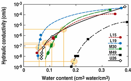
Core samples were retrieved up to depths of 30 m using a piston core barrel lined with aluminum core liners. Cores were capped with plastic caps, sealed with electrical tape, wrapped in plastic, and sealed in heat-sealed aluminum pouches to preserve water content (Izbicki and others, 2000). Only about one sample in ten came from a layer sufficiently free of large particles and wet enough for successful extrusion and recoring, as needed for the SSC method. Five samples from three boreholes were usable. These had mostly very fine to medium sand, with some silty material and very little to no gravel. The figure below shows SSC-measured hydraulic properties for the five samples.
Steadiness of flow was not a problem in this investigation, which is described in detail by Nimmo and others (2002), because of the considerable depths of sampling. The matric pressure in such a layered medium, however, is not uniform, even with steady flow. A nonuniform matric pressure, with steady or unsteady flow, violates the assumption of unit gradient gravity-driven flow.
The possibility that matric pressure gradients might cause an intolerable deviation from pure gravity-driven flow was investigated with a a one-dimensional numerical simulator. This model solves Darcy’s law, given a downward water flux, to obtain values of matric pressure as a function of position within the unsaturated zone beneath the wash. The model was used to estimate the effect of different layers and layer boundaries on matric pressure gradients, and to evaluate the error resulting from the assumption that these gradients are negligible. At a typical location the model recognizes 42 discrete layers. The model requires information about hydraulic properties of the media -- specifically, a K(q) function -- as input. With too few point measurements to directly represent a multilayer heterogeneous system, the unsaturated hydraulic properties of the unsaturated zone to 32-m depth were approximated using scaling assumptions and estimation of scale factors from lithologic descriptions. In other words, surrogate hydraulic property data were generated to supplement the high-quality SSC measurements. This was done assuming the media in all layers are Miller similar. With this assumption, properties of unmeasured layers could be scaled from those of a base set of parameter values derived from those of the measured samples.
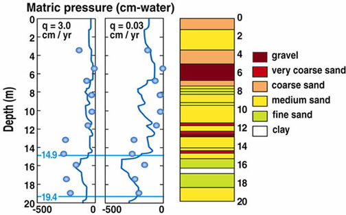
Two sets of simulated matric pressure profiles, with flux densities of 3 cm/yr and 0.03 cm/yr, are shown in the figure (left). Soil lithology is also shown as a function of depth. Each profile has numerous short intervals that are nearly straight and vertical; between these are intervals that show steeper gradients. A given sample measured using SSC may have come from a 4-cm segment of the profile that either does or does not include an interval with a steep gradient. Model results for the Oro Grande Wash showed a negligible probability of the matric pressure gradients leading to flux errors greater than a factor of 2. This magnitude of uncertainty was considered acceptable in the Oro Grande Wash study, though it would not be tolerable in all applications.
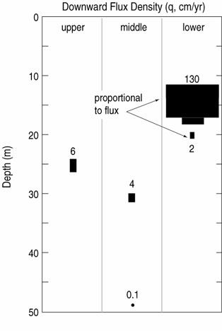
Given the evidence for steady flow driven by total force within a factor of 2 of earth gravity, K values from the measured curves were taken to be estimated downward flux densities. These are graphed in the figure below (right)as a function of depth for three boreholes in upper, middle, and lower reaches of the channel. The size of the symbols in the figure is proportional to the flux density.
The combination of a highly stratified profile with a linear, rather than planar, source of water at the earth’s surface brings added difficulty to the estimation of recharge. Even though the measurements are from considerable depth and likely to be in the zone of steadiness, the five estimated flux densities vary considerably. They decline with increasing depth, as would be caused by unsaturated-zone lateral flow away from the wash. Lateral flow is likely to be enhanced by the severe layer contrasts. The figure below (left) shows contour plots of relative downward flux predicted from a two-dimensional Darcian simulation similar to the one described above, and applied to a cross section perpendicular to the channel. Each contour encloses a specified fraction of the total input flux. For example, 40% of the flux will be within the area bounded above by the 0.4 contour; the narrower this region at any given depth, the more spatially concentrated the flux under the streambed at that depth.The modeled pattern of flux is as expected, with spreading beneath and away from the wash.
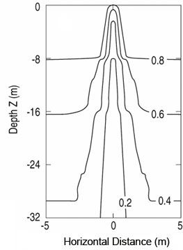
This Darcian approach could be applied to the Oro Grande site to give downward flux densities at individual points because of the support from numerical modeling of flow through the entire profile. The key feature that makes this approach feasible is that the quantitative final results are strongly sensitive to the few high-quality K(q) measurements but weakly sensitive to the less accurately known data. Because of the lateral spreading, however, to estimate total recharge from the stream channel will require further investigation to determine the effective width of the zone of significant downward flow at one or more depths where the downward flux density is known.
If y gradients are great enough to invalidate the assumption, as might result from substantial variations in hydraulic properties associated with textural contrasts between layers, the water fluxes will be incorrectly inferred.
| National Research Program | USGS | Water Resources | Unsaturated Zone Flow Project Home Page |