

| Kim Perkins (kperkins@usgs.gov) | John Nimmo (jrnimmo@usgs.gov) | Unsaturated Zone Flow Project Home Page |
The Darcian method applied to steady flow conditions in the unsaturated zone (Nimmo and others, 1994) can produce high-quality local recharge estimates at diverse locations to provide a standard of comparison, for example between humid regions where streamgaging data are useful for recharge estimation and drier regions where they are not. This method is based on knowledge of the unsaturated hydraulic conductivity (K) at a point (usually deep) in the unsaturated zone where flow is downward and steady.
If flow under field conditions is steady and driven by gravity alone, then, according to Darcy’s Law, downward percolation rate will be numerically equal to the hydraulic conductivity of the material at the measured in-situ water content. The Darcian unit-gradient method (Sammis and others, 1980, Nimmo and others, 1994) was originally used to estimate long-term average recharge rates in arid regions with thick unsaturated zones where, below some depth, flow is considered to be steady and driven by gravity alone. In shallower unstaurated zones in some environments, some form of this method may be applicable if changes in water content are slight and recharge rates may vary little over the course of the year or may exhibit a seasonal, repetitive pattern of variability. The Darcian method does not necessarily indicate total recharge as it only accounts for diffuse, matrix flow. Recharge due to preferential flow is inherently non-Darcian and, if significant, must be determined separately.
In the unsaturated zone, Darcy’s Law may be represented in head units by the equation:
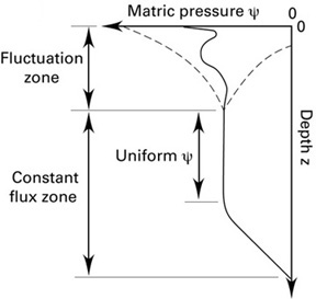
q= -K(q) [dy/dz+1]
where q = flow rate [LT-1], K = hydraulic conductivity [LT-1], q = volumetric water content [dimensionless], dy/dz = matric potential gradient [dimensionless], and dz/dz = 1 = gravitational potential gradient [dimensionless]. Under the unit-gradient assumption, matric potential is constant with depth (i.e., dy/dz = 0, see figure, left) and gravity is the only driving force, therefore q numerically equals the hydraulic conductivity of the medium at the water content of the depth interval where the dy/dz = 0 condition holds. If the K corresponding to the in-situ water content is known, that K may be interpreted as a recharge rate (below, right). When conditions closely approximate the ideal as pictured above, because of the dampening and averaging of moisture fluctuations in the upper layers of soil, the flux estimated in the uniform y zone is a long term average. Unsaturated hydraulic conductivity is seldom measured at the exact field water content, therefore, interpolation of the measured, highly nonlinear K(q) relationship in general is critical to recharge estimation. Because of the strong sensitivity of K to q, the field value of q must be measured with a high degree of accuracy also.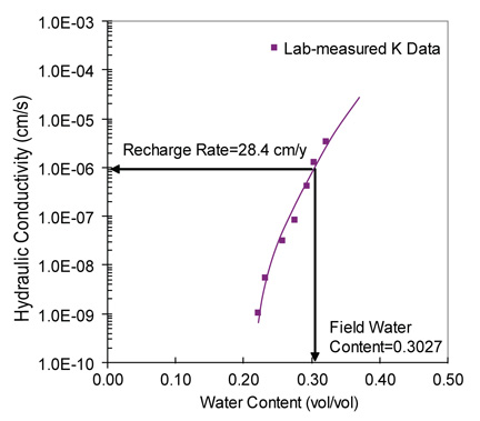
Ideally, the Darcian method for determination of point recharge rates utilizes accurately measured hydraulic conductivity (K) at the existing field water content on core samples from a deep unsaturated zone with constant, gravity-driven flow. The steps required to apply the method are as follows:
Certain critical issues must be addressed with proposed application in a new location including:
Four case study sites illustrate the applicaiton of this method in diverse locations (click site name for details):
| Palouse, Southeastern WA | Imperial, Southwestern NE | Western Mojave Desert, CA | Glassboro Study Area, Southwestern NJ | |
|---|---|---|---|---|
| Description | Semi-arid, rolling hills topography, loess deposits, agricultural land, ~ 7-30 m to water table, mean annual precipitation 50 cm | Semi-arid, Northern High Plains low relief, windblown loess and sand, rangeland, ~29m to water table, mean annual precipitation 50 cm | Arid, coarse to fine textured alluvial deposits, ~ 60-300 m to water table, mean annual precipitation 15 cm | Humid, coastal plain physiographic province, low relief, sandy soils, mixed urban and agricultural land, ~8 m to water table, mean annual precipitation 109 cm |
| Unsaturated zone flow character | Steady flow, uniform profile | Steady flow, non-uniform profile | Steady flow, non-uniform profile | Possibly seasonally steady or unsteady, relatively uniform profile |
| Evidence for steadiness | Matric potential profile constructed from gravimetric samples and lab-measured retention curves | Continuous heat dissipation probe (HDP) data for several years | Assumed steady due to depth in unsaturated zone (> 15 m) | Multiple (4-time) water content measurements |
| Major cause of uncertainty in steadiness | Retention curve error | HDP error (+/- 100 cm) | Lack of repeat sampling | Temporally sparse data |
| Uncertainty in field water content | Less than ± 3% | Less than ± 3% | Less than ± 3% | Less than ± 10% |
| Flux calculated from measured K | 11 cm/y | 13 cm/y at 20 m depth | 2, 4, and 6 cm/y for 3 locations* |
Range of 13-50 cm/y |
| Flux calculated from Rosetta-predicted K | 2800 cm/y | 630 cm/y | 1, 100, and 14 cm/y for 3 locations* |
Range of 600-1000 cm/y |
| Flux calculated from Mualem-predicted K | 5000 cm/y | 3.1 cm/y | <1 mm/y for 3 locations* |
Range of 14-18 cm/y |
| Flux calculated from Mualem-predicted K with known saturated K | 35 cm/y | 5.4 cm/y | <1 mm/y for 3 locations* |
Range of 3.2-6.8 cm/y |
| Other estimates of recharge | Water budget 6.3 cm/yr | Tritium 7 cm/y | Tritium 7 cm/yr | Water budget 33-49 cm/yr |
*at depths in the range of 20-30 m below land surface
View all references cited on this site
Acknowledgement: This website was produced with support from the the US Geological Survey's Ground Water Resources Program.
| National Research Program | USGS | Water Resources | Unsaturated Zone Flow Project Home Page |